Wellington City: Panoramic view of Wellington harbour, surrounded by buildings and houses

Te Whanganui-a-Tara Wellington City

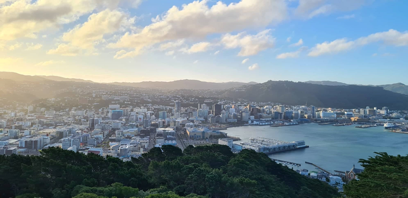
The capital city lies within the collision zone between two tectonic plates and sits on top of one of the zone's most active geological faults - the Wellington Fault. Many other active fault lines pass through and near Wellington City, which makes for a significant earthquake and tsunami risk.

Warning icon Wellington alerts: what you need to know

Last updated: 15:56pm 16/02/2026

WREMO Alert Icon  Severe Weather white

Severe weather

Severe weather event

Monday 16 Feb 2026 - 16:12pm

4pm 16/02/2026 update

Power outages 
11,000 houses without power across the region. 
4,000 houses have had power restored. 
While crews are working to restore power as quickly as possible some properties may remain without power overnight.

What to do during a power outage:
- If you lose power, unplug major appliances. This will reduce the power surge and possible damage when power is restored
- Don’t use candles - they're a fire risk. Use a torch instead!
- If you are medically dependent on power, in an emergency call 111 or go to your nearest medical centre
- Treat all downed lines/electrical equipment as LIVE at all times
If you have been affected by a power outage or want to check on your area, more information and advice is available on your electricity company website:
https://www.welectricity.co.nz/outages
https://outages.powerco.co.nz/
https://electra.co.nz/outages/

Flooding 
Surface flooding has occurred across the region, with particular concern in the Waiwhetu and Naenae areas of Lower Hutt, as well as in southern Wairarapa. 

Floodwater is dangerous as it often contains debris and is contaminated, which can make you sick and cause harm. Be careful around floodwater and when cleaning up after flooding.

If you do become sick, contact your GP in the first instance or Healthline for advice 0800 611 116. 

Road closures 
We have road closures across the region, including: 
Cape Palliser Rd closed due to combination of wind, coastal inundation and flooding.  
Ruamāhanga River levels are being closely monitored at the Waihenga Bridge (SH53) near Martinborough. 
Significant number of local road closures throughout the Wairarapa region. 
 
Swells/wastewater 
The high tide window of 4pm-6pm combined with the ongoing heavy swells is a risk that is continuing to be monitored.

Of particular concern is if the high tide exacerbates river levels in the Waiwhetu Stream and Wairarapa rivers and increased risk of swells inundating roads on Wellington’s south coast, Eastbourne and Wairarapa Coast. Further updates will be provided if this occurs.

Transport 
Hutt Valley, Johnsonville and Kāpiti Line train services have resumed on Saturday timetables. 
Wairarapa services are continuing to be replaced by bus.

Harbour ferries and Cook Strait ferries have been cancelled today.
 
Emergency services 
Fire and Emergency New Zealand responded to 555 calls from across the region overnight. 
 
Schools   
A large number of schools closed for the day around the region. Your school will advise if they are open tomorrow.

Read emergency event information for the Wellington Region.

Wellington: what's affected?

Last updated: 15:56pm 16/02/2026

Warning icon

Power impacted in the Wellington area

Warning icon

Public Transport impacted in the Wellington area

Warning icon

Roads impacted in the Wellington area

Warning icon

Schools impacted in the Wellington area

Warning icon

Utilities impacted in the Wellington area

Warning icon

Water impacted in the Wellington area

Wellington City is New Zealand’s Capital, home to Central Government, and has a population of approximately 202,737.

Wellington City Council Facebook Feed

Contact Information

Contact Wellington City Council:   

Phone: 04 499 4444 

Email: info@wcc.govt.nz 

Website: http://wellington.govt.nz/ 

Wellington City Tsunami Evacuation Maps

Wellington City Community Emergency Hubs